
Natural Attractions of Uzbekistan Worth Visiting
Uzbekistan is not only a country with a rich historical heritage and magnificent architecture but also a land of astonishing natural attractions. From majestic mountains to vast deserts and picturesque lakes, every part of this unique region offers breathtaking views and unforgettable experiences. In this article, we will share the most impressive natural sites in Uzbekistan that every traveler who appreciates the beauty and diversity of the surrounding world should visit.
1. Mountains
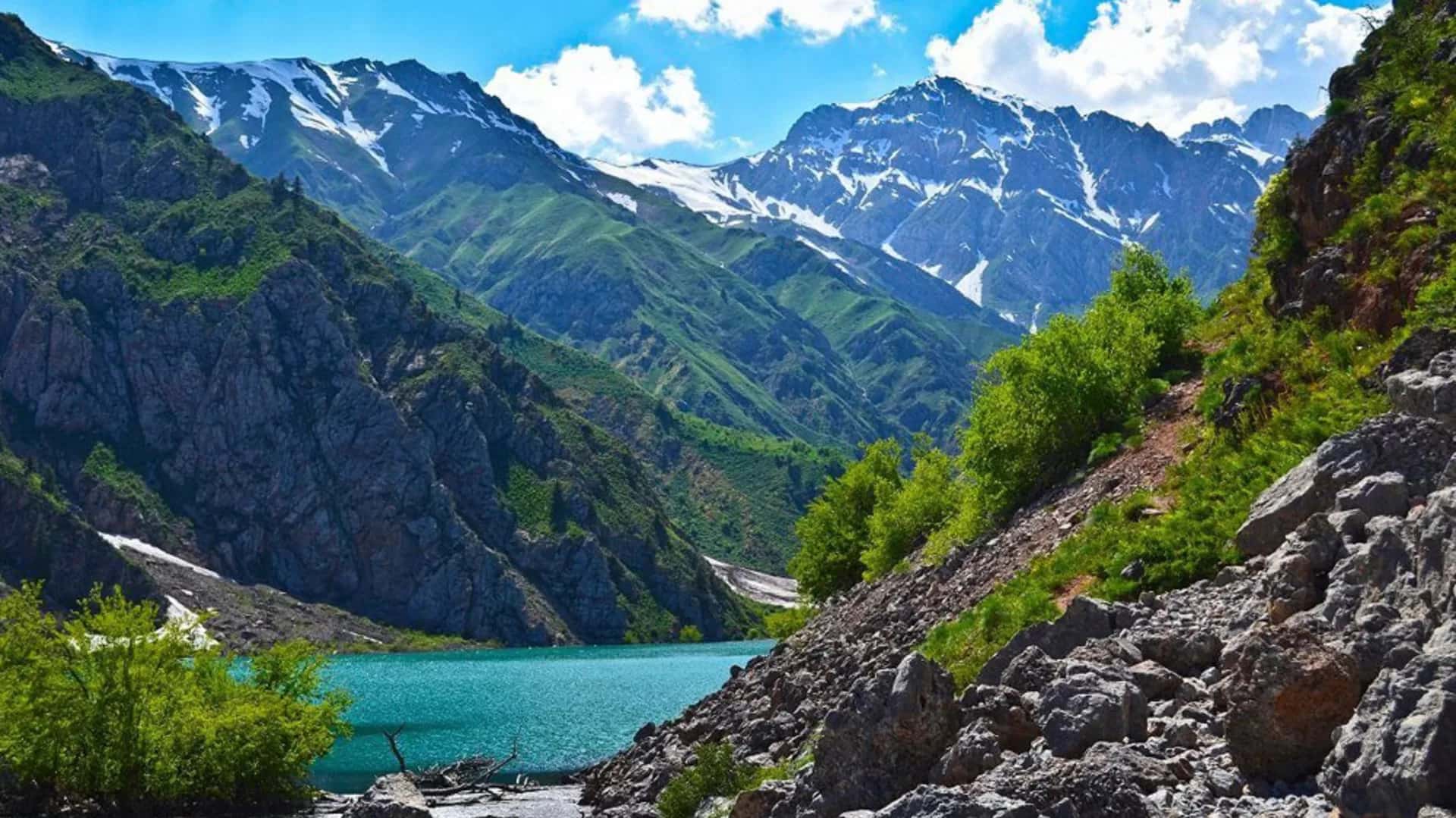
Tian Shan. Translated as "Heavenly Mountains," it is located in the eastern part of Uzbekistan and stretches along the borders with Kazakhstan and Kyrgyzstan. It is home to the highest point in Uzbekistan — the Hazret Sultan peak, standing at 4,643 meters. The mountain range is renowned for its glaciers, alpine meadows, and crystal-clear lakes, such as Lake Issyk-Kul, located at an altitude of 1,600 meters above sea level.
Pamir-Alay. Situated in the southern part of the country, primarily in the Surkhandarya and Kashkadarya regions. Here, nature has crafted unique landscapes with steep cliffs and deep gorges. Pamir-Alay is known for its extreme conditions, making it attractive to mountaineers and trekking enthusiasts. One of the region's highlights is the Anzob Pass, offering breathtaking views of the surrounding mountains.
Tourism and Outdoor Activities. The mountains of Uzbekistan offer numerous opportunities for active recreation: mountaineering, rock climbing, hiking, and skiing. National parks and reserves such as the Chatkal Biosphere Reserve and Zaamin Nature Park attract tourists with their wild nature and rich biodiversity. For cultural tourism lovers, Uzbekistan also offers visits to ancient cities like Samarkand and Bukhara, located near the mountain ranges and listed as UNESCO World Heritage sites.
The mountains are not only a natural treasure but also an important part of Uzbekistan’s cultural and historical heritage, creating unique opportunities for unforgettable journeys and discoveries.
“Ugam-Chatkal National Park”
One of the largest national parks in Central Asia. It is located in the mountains of the Western Tian Shan and is home to numerous rare species of plants and animals. The park features picturesque lakes, waterfalls, gorges, and forests.
«Chimgan-Chatkal Mountain Resort»
This is a popular ski resort located in the mountains of the Western Tian Shan. The resort offers numerous opportunities for skiing, snowboarding, and other winter sports.
2. Lakes
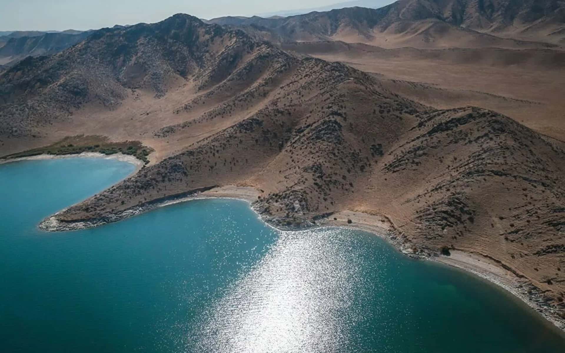
Uzbekistan is renowned for its picturesque lakes, each possessing unique natural features. One of the well-known lakes is Aydarkul. Located in the northeastern part of the country, it was formed as a result of excess water from the Sardarya Reservoir in the 1960s. This artificial lake impresses with its size and is a popular destination.
«Айдаркуль»
Aydarkul (Uzbek: Aydar ko‘li) is a large lake in the northeastern part of Uzbekistan, created as a result of the construction of a reservoir in the Arnasay lake system.
In the 1960s, the Syrdarya River was dammed and the Shardara Hydroelectric Power Station was built. The sluices controlled the water level, but during a severe flood in 1969, they were opened because the dam could not handle the flow. From February 1969 to February 1970, 60% of the Syrdarya's annual flow (21 km³) was diverted into the Arnasay lowland, forming the lake. Since then, it has regularly received inflows from the Syrdarya whenever the Shardara reservoir overflowed.
In 2005, the water volume was 44.3 km³. In 2006, the surface area reached 3,478 km², with a length of 160 km and a width of 34.8 km. The water salinity is only 2 grams per liter. The maximum elevation above sea level is 247 meters.
Various fish species were introduced into the lake: common carp, zander, bream, catfish, asp, sabrefish, and snakehead, which established the basis for fishing. Annually, between 760 and 2,000 tons of fish are harvested from the lake system.
The fauna of the Kyzylkum Desert is complemented by many waterfowl that migrate here from the Aral Sea.
Located far from populated areas, only 345 families (about 1,760 people) live near the lake. The region holds great potential for fishing, nomadic livestock breeding, tourism, and in the future — for nuclear power plant construction. The lake does not freeze in winter.
«Денгизкуль»

The lake is located in the south of Bukhara region, in the Alat district, near the border with Turkmenistan. It lies in a tectonic basin at an altitude of 181.5 meters above sea level.
The shoreline of the lake is variable. As of 1987, its dimensions were: length – 43.3 km, maximum width – 9 km (at its narrowest point – 22 m), area – 267 km², volume – 2.7 km³.
Dengizkul is replenished by water from several collectors and seepage from fields. During the flood period, the lake connects with the Zeravshan River’s Taikyr branch. The water is saline and possesses healing properties. There is a layer of table salt about half a meter thick at the bottom.
Historically mentioned since the Middle Ages. In the 10th century, the Arab geographer Ibn Hawqal called it Bahr ul-Bukhara – the "Bukhara Sea." Historian Muhammad Narshakhi wrote that the lake was 20 farsakhs wide (140–160 km).
In the 1960s and early 1970s, the lake experienced significant seasonal fluctuations in water level: from 40–60 km² with a depth of 25–30 cm to 80–100 km² with a depth of 1–1.5 m. In the 1970s and 1980s, due to land development for cotton cultivation in the south of Bukhara region, the lake expanded due to discharge waters.
«Urungach Jade Lakes»

Urungach, whose name translates as "bright jade," is located in the picturesque Ugam-Chatkal National Park, just 160 km from Tashkent.
These magnificent bodies of water were formed by the collapse of a rock that became a natural barrier. The water level in Little Urungach Lake varies greatly depending on the season and river inflow.
Four kilometers above the smaller lake lies Upper Urungach, which, unlike its smaller neighbor, never dries up, even during the hottest months. The landscape and the lakes themselves differ noticeably: Upper Urungach captivates with its bright turquoise color and is twice the size. This place is also known for its diverse flora and fauna, including unique plant species and rare animals, making it a true corner of wilderness. Discover the beauty of this high-mountain paradise and immerse yourself in its natural harmony!
Little Urungach
Elevation above sea level: 1227 m.
Average depth: 4 m.
Maximum depth: 10.4 m.
Upper Urungach
Elevation above sea level: 1528 m.
Average depth: 12.6 m.
Maximum depth: 21.4 m.
«Tuzkan»

Tuzkan (Uzbek: Tuzkon, Tuzkon) is a brackish lake without outflow, located in Uzbekistan and part of the Arnasay system. It is the second largest lake in the system after Aydarkul, covering an area of 705 km², with an elevation of 237 meters above sea level. Unlike other bodies of water in the Arnasay system, Tuzkan has an ancient natural origin, although its shape has been altered by human activity.
It is situated in the Farish district of Jizzakh region, 56 km northeast of the city of Jizzakh, and lies in the eastern part of the Kyzylkum desert. In the Arnasay system, it occupies a southern position and connects to Aydarkul in the northwest. Tuzkan stretches from northwest to southeast and has an approximately triangular shape: about 35 km in length, with a width varying from 22 to 25 km, and bays on the eastern shore extending up to 35 kilometers. Like other lakes in the system, it lacks stable outlines, and about 15–20% of its water surface is overgrown.
The shoreline in the northeast is indented, creating numerous narrow shallow bays, some of which are separated as distinct water bodies. Most of the surrounding area consists of salt flats, and this part of the lake is also rich in islets. The surrounding landscape is desert, partially covered with saxaul shrubs and reeds.
To the south, the shoreline straightens, and in the southern part, brackish rivers Kly (or Sanzara in the lower course) as well as the Akbulak and central collectors flow into Tuzkan. Nearby are the saline lakes Togay and Tuzchikudukkul, and the area near the lake is marshy. The southwestern shore borders low mountains of Pistalitau, which are an offshoot of the Nurata Range, while to the west, sands and hilly terrain approach Tuzkan.
«Charvak Reservoir»

In 1970, a majestic artificial lake appeared on the Chirchik River, becoming the largest reservoir in the region. To create it, an impressive dam 168 meters high was constructed, essential for the operation of the Charvak Hydroelectric Power Station. The reservoir covers an area of 37 km², with a shoreline stretching over 100 km! This lake has become a true paradise for the residents of Tashkent — its picturesque shores are home to resorts and sports camps, and a ring road has been laid around it.
The surroundings of the reservoir are rich with fascinating historical sites. Archaeologists discovered an ancient human settlement on the banks of the Paltau River, and near the village of Khodzhikent lies the famous Chinar Cave, known for its unique petroglyphs. In the village of Bogiston, located on the lake’s shore, two outstanding figures were born — Sheikh Ubaydullah Akhror and Sheikh Khovendi at-Takhr, whose mausoleums can be seen in Tashkent. The waters are inhabited by fish species such as carp, whitefish, and trout. However, most importantly, during the summer heat, the lake offers a refreshing coolness to visitors, making it an ideal place for rest and recreation.
The surroundings of the reservoir are rich with fascinating historical sites. Archaeologists discovered an ancient human settlement on the banks of the Paltau River, and near the village of Khodzhikent lies the famous Chinar Cave, known for its unique petroglyphs. In the village of Bogiston, located on the lake’s shore, two outstanding figures were born — Sheikh Ubaydullah Akhror and Sheikh Khovendi at-Takhr, whose mausoleums can be seen in Tashkent. The waters are inhabited by fish species such as carp, whitefish, and trout. However, most importantly, during the summer heat, the lake offers a refreshing coolness to visitors, making it an ideal place for rest and recreation.
«Arashan High-Mountain Lakes»

They include 4 bodies of water: Arashan, Khoja Arashan, Big Arashan, and Small Arashan. All are located at elevations ranging from 2774 to 2880 meters above sea level and are classified as high-mountain moraine lakes. The length of Big Arashan is 750 meters, and its width is 250 meters. Nearby is a thermal spring with hydrogen sulfide water, maintaining a constant temperature of 36.7°C throughout the year. Just above the spring lies a Sufi shrine, consisting of a massive stone serving as a tombstone, and a grave decorated with mountain goat horns. According to legend, this is the burial place of the saint Arashan-buvi.
The summit lakes, situated above 3000 meters, fully thaw only by early July. Due to their location in deep valleys surrounded by steep slopes, these lakes have become the subject of many legends. One of them tells of numerous horsemen who fell from dangerous mountain trails and perished in these waters. The legends say that sometimes, especially during bad weather, sounds of horse neighing and cries of the fallen can be heard from the depths of the lakes. Notably, Small Arashan has a regular shape, giving the impression of an artificial origin.
The summit lakes, situated above 3000 meters, fully thaw only by early July. Due to their location in deep valleys surrounded by steep slopes, these lakes have become the subject of many legends. One of them tells of numerous horsemen who fell from dangerous mountain trails and perished in these waters. The legends say that sometimes, especially during bad weather, sounds of horse neighing and cries of the fallen can be heard from the depths of the lakes. Notably, Small Arashan has a regular shape, giving the impression of an artificial origin.
«Badak Lake»

A true gem of the Ugam-Chatkal National Park, situated at an altitude of 1700 meters above sea level. The name of this natural wonder, of Turkic origin, translates as “wide.” Stretching over a kilometer in length and more than 200 meters in width, the lake reaches a maximum depth of 23.2 meters.
Its unique feature lies in the changing colors depending on the time of day: in the morning it sparkles with greenish-blue hues, by noon it takes on a gentle blue color, and at sunset it turns silvery.
Although the lake is only 10 kilometers away, its elevation can pose a challenging ascent for travelers due to the long climb to the dam. Along the way, one can enjoy picturesque small ponds surrounded by shaded spots, perfect for rest and relaxation.
«Kanbeshbulak Meteorite Lake»

A small lake, approximately 800 meters in diameter, located in the Hamkan tract in the western part of Surkhandarya region. According to scientists, this lake is remarkable because it most likely formed not through natural processes, but as a result of a meteorite impact, thus representing a meteorite crater.
In the soil and river sand at the Takhtakaracha pass in the Karatyubin mountains, tektites are abundant—small glassy bodies formed under high temperatures due to meteorite impacts on the Earth’s surface, originating from cosmic or terrestrial material. In the mountains surrounding the Kashkadarya basin to the east, large, palm-sized porous and glassy meteorite fragments are found, usually scattered across areas about five meters in diameter, along with other stones of clearly cosmogenic origin.
After analyzing the fall of fragments, their sizes, and the distances between impact points, scientists concluded that a large meteorite body that left such traces must have fallen in the Hamkan tract, creating a crater that later filled with water and was named Kanbeshbulak Lake. The meteorite origin of the lake basin is also indicated by shattered, explosion-like red sandstones composing its slopes. Moreover, the analysis of the rocks forming the lake zone suggests that it could not have formed naturally through water action or tectonic changes.
3. Caves
The caves of Uzbekistan are remarkable natural sites that attract researchers and tourists with their unique beauty and historical significance. These underground wonders conceal not only captivating geological formations but also numerous archaeological discoveries.
«Tamerlane»
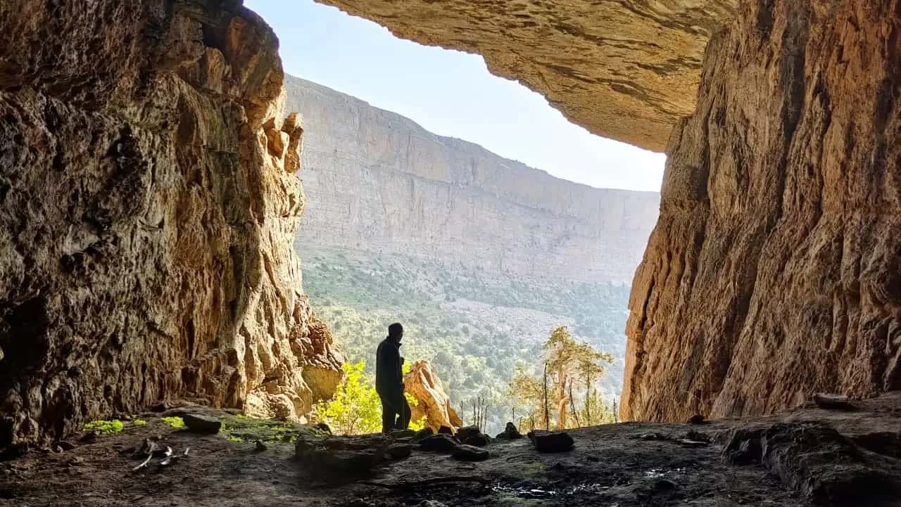
Tamerlane’s Cave (Amir Temur Gurkani) is located in the Gissar Mountains, near the village of Tashkurgan and the Kyzylgaza Pass, in the Yakkabag district of Kashkadarya region, Uzbekistan. The cave entrance is situated at the foot of the Eastern wall of a canyon carved by a river through limestone.
Accessing the cave is challenging — a guide is required. One may attempt to find a path descending stone steps into a canyon more than 200 meters deep. The canyon, about 6 kilometers long, resembles the canyon from the movie “MacKenna’s Gold.” Rocky towers surround it on all sides. Descending to the canyon floor, you enter a dark stone “bag.” The canyon width varies from 12 to 60 meters, with walls rising 200-300 meters high. Crossing to the right riverbank and climbing up a scree slope covered with shrubs and juniper, you reach the cave entrance.
The entrance resembles an arch up to 6 meters high and 7 meters wide. Inside, a corridor 10-15 meters high leads onward. The walls are decorated with calcite deposits and stalactites. The main corridor extends 400 meters into the mountain with almost no side branches, making it impossible to get lost. In the far part of the corridor, the walls and ceiling narrow, requiring crawling.
The distance between floor and ceiling is 45-60 cm, unsuitable for large tourists or those with claustrophobia. After passing several narrow sections, you enter a huge collapse hall measuring 60 by 30 meters, with a ceiling height of 70 meters. The hall is humid, the floor is covered with large stones, and several offshoots exist. At the farthest hall lies a lake formed by a 10-meter waterfall. Water seeps through the stones, causing the lake to disappear by September-October. It is recommended to bring a bright flashlight to enjoy the waterfall spectacle. The visit takes about 3 hours.
A legend is associated with the cave, saying that Tamerlane and his comrades found shelter here and prepared for military campaigns. However, this is unlikely, as descending into the canyon on horseback is difficult. In front of the cave stands an old wall made of large stones, probably built by shepherds.
«Hazrat Daud»

One of the well-known sacred sites of Uzbekistan, the Hazrat Daud (Saint David) Cave, is located 40 km southwest of Samarkand, within the village of Aksay. This place is revered in three world religions and surrounded by numerous legends shared by locals with pilgrims who come to seek the saint’s help, healing from illnesses, or the fulfillment of cherished wishes.
According to an Arab legend, the biblical King David was sent by God to Asia to preach monotheism. Here, in Uzbekistan, he angered the local Zoroastrians who began to persecute him. David took refuge in the mountains and, calling upon God, was able to part the stones with his hands to hide inside the mountain.
Another legend says that David was searching for a secret place to rest before battling Goliath. Jinns transported him to a mountainous area near Samarkand, but ifrits found him and brought Goliath. David prayed to God to hide him, as he was not ready for the fight. He began digging into the rock, which became as soft as wax in his hands. David passed into the depths of the rock, leaving Goliath empty-handed.
It is believed that any wish comes true in the Hazrat Daud Cave. To reach it, one must climb 1,303 steps to the mountain peak. At the summit, there is an old mosque for prayer. Then descend 200 steps down to the cave. The cave is a tunnel ranging from 0.5 to 4 meters wide, up to 15 meters high, and up to 30 meters long. At the end of the tunnel, you can see the imprints of Daud’s palms and feet. Wishes should be made by touching them.
Climbing 2,000 steps is not feasible for every pilgrim. Locals offer rides on donkeys or horses. Along the staircase, there are stalls selling water, medicinal herbs, wild animal skins, and souvenirs.
«Khodzha Gur Gur Ota Massif»

Khodzha Gur Gur Ota, which translates as "father of all caves," is a unique corner of wild and rugged nature situated at an altitude of 3,700 meters above sea level. The majestic, flattened summit of this mountain massif plunges into a 500-meter cliff on one side and descends into deep canyons with stunning fissures on the plateau on the other.
Here you can see fossilized dinosaur tracks, basalt formations, and fragments of stones in the most unusual shapes, as well as sacred burial sites of significant historical importance. The vertical slopes abound with entrances to numerous caves, many of which remain unexplored to this day. Climbing to the summit of the massif, you will feel as if standing on a mighty wall separating one world from another and will be able to enjoy breathtaking views of the surrounding landscape, filled with the grandeur of nature.
Here you can see fossilized dinosaur tracks, basalt formations, and fragments of stones in the most unusual shapes, as well as sacred burial sites of significant historical importance. The vertical slopes abound with entrances to numerous caves, many of which remain unexplored to this day. Climbing to the summit of the massif, you will feel as if standing on a mighty wall separating one world from another and will be able to enjoy breathtaking views of the surrounding landscape, filled with the grandeur of nature.
«Kok-Su River Valley»
Koksu ("blue water") is a mountain river in the Tashkent region, flowing into the Charvak Reservoir near the village of Brichmulla. The river is about 60 km long. The Koksu River Gorge is one of the most beautiful places in the Western Tian Shan.
Despite its proximity to populated areas, this place is very narrow, and there is no wide road leading deep into the gorge.
Therefore, civilization has left almost no traces here.
The river is fed along its entire length by numerous mountain streams. And in each of these tributaries, you can find such fascinating natural spots as waterfalls, lakes, rocky cliffs, narrow passes, snowfields, caves, and more.
4. Waterfalls, reserves, monuments
«Kitab State Geological Reserve»

The reserve is located in the picturesque spurs of the Zarafshan Range, on the banks of the Jindarya River, 45 km east of Kitab. It is relatively small: its territory, situated at elevations from 1300 m to 2650 m above sea level, covers almost 40 thousand hectares. The mountains are dissected by unique gorges distinguished by their beauty, depth, and variety, and are covered with stands of juniper. The northeastern part of the reserve encompasses the scenic Shirdor tract, offering panoramic views of the snow-capped peaks of the Gissar Range and Mount Hazret Sultan.
The main attraction of the reserve is the marine sedimentary deposits with a thickness of 4130 meters! This distinctive layered "cake" of rock was "baked" by nature 370-470 million years ago during the Paleozoic era. By examining the "filling" of the Kitab "cake," one can closely trace what happened to the Earth's surface over more than one hundred million years. What is represented in a fragmented manner in other regions of the planet is here brought together in one very small area by nature.
The main attraction of the reserve is the marine sedimentary deposits with a thickness of 4130 meters! This distinctive layered "cake" of rock was "baked" by nature 370-470 million years ago during the Paleozoic era. By examining the "filling" of the Kitab "cake," one can closely trace what happened to the Earth's surface over more than one hundred million years. What is represented in a fragmented manner in other regions of the planet is here brought together in one very small area by nature.
«Paltau Waterfall. Obi-Rahmat Grotto»

The Paltau Valley is located 100 km from Tashkent, along the banks of the Chatkal River. One of its main attractions is the archaeological monument, the Obi-Rahmat grotto, where ancient humans once lived during the Paleolithic period, as well as the famous Paltau waterfall, which has a height of 38 meters. The streams, rapidly falling from an impressive height, create an impression of powerful and magnificent natural force.
The cave is situated on the left bank of the Paltau gorge, approximately 4 kilometers from its confluence with the Chatkal. At an altitude of 1250 meters above sea level, along the stream bed, there are limestone cliffs where a strong spring bursts forth near a flat summit, which may have carved numerous holes in the limestone in ancient times. Right at the entrance to the grotto, a waterfall cascades down from the cliff’s height, and the action of the water likely provided ancient people access to the underground galleries.
The cave is situated on the left bank of the Paltau gorge, approximately 4 kilometers from its confluence with the Chatkal. At an altitude of 1250 meters above sea level, along the stream bed, there are limestone cliffs where a strong spring bursts forth near a flat summit, which may have carved numerous holes in the limestone in ancient times. Right at the entrance to the grotto, a waterfall cascades down from the cliff’s height, and the action of the water likely provided ancient people access to the underground galleries.
«Maidanak High-Mountain Observatory»

Located 45 kilometers from the city of Shakhrisabz, in the Kamashin district of Kashkadarya region, is the Maidanak Astronomical Observatory, home to the largest 1.5-meter telescope in Central Asia. The observatory opened its doors in 1970 and today represents a modern research facility equipped with the latest technology. It belongs to the Mirzo Ulugbek Astronomical Institute and actively collaborates with international scientists in the field of astronomical research.
Situated at an altitude of 2,650 meters above sea level, amidst the majestic Gissar mountain range, the observatory stands out for its unique geographic location and ideal atmospheric conditions. The powerful telescope allows for highly precise studies of variable stars and galaxies, examination of cosmic object clusters, as well as monitoring changes in quasars and supernovae.
As one of the leading observatories in the Northern Hemisphere, over 80 asteroids, 4 comets, and a new minor planet have been discovered here. This minor planet was named “Samarkand” and was registered in the International Minor Planet Catalog after being discovered by Uzbek astronomers in July 2010. It is known that this small planet completes an orbit around the Sun in approximately four years, located between the orbits of Mars and Jupiter.
The observatory occupies a significant area of about 40 hectares. Surrounded by mountains, the sky feels especially close, and the stars are within reach. Here, one can find fossils of marine organisms, an ancient dormant volcano, and the fresh air combined with the breathtaking grandeur of the landscapes creates an unforgettable atmosphere.
«Koytash Stone Garden»

Represents a unique natural formation that attracts the attention of researchers and tourists alike. The name "Koytash" originates from the Uzbek words "qo’y" (sheep/rams) and "tosh" (stone), likely related to the extensive pastures for grazing livestock and the presence of large boulders in this area.
Satellite images clearly reveal a scatter of stones covering an area with a radius of about 4 kilometers. This is especially noticeable on Yandex maps. The morning hours in Koytash are often characterized by cloudiness and a light haze, giving the landscapes a special atmosphere.
The mountain slopes surrounding Koytash are strewn with stones of whimsical shapes. Some resemble guards wearing protective helmets, others the faces of animals, or even giant mushrooms. Particularly intriguing are the stones with smooth vertical cuts and holes, whose origins remain a mystery.
According to scientific literature, these stone formations arose as a result of acid leaching of pyroxene rocks, specifically hedenbergite. However, the leaching process from bottom to top still raises questions among researchers.
Koytash Garden is a place where nature has created astonishing sculptures that captivate the imagination and inspire admiration in all who visit.